Published: 12:43 AM, 09 October 2018 Last Update: 12:45 AM, 09 October 2018
Voyage along Nile River
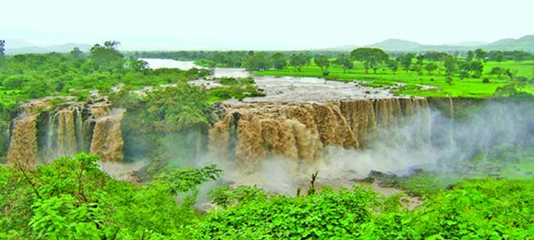 Blue Nile Falls at Ethiopia.
 Nile River, flowing through Northeastern Africa is the longest river in the world. The name Nile is derived from the Greek word Neilos, which means river valley. It has a length of about 6,650 km (kilometers) and drains an area of approximately 3,349,000 square kilometers.
The Nile River basin has witnessed evolution and decay of many civilisations of the ancient world. Egyptian civilization and Sudanese kingdoms have depended on the river since ancient times. These people were the first to practice agriculture and used plow. Two principal streams of Nile are the Blue Nile and the White Nile. Its water resources are shared by eleven countries.
English explorer John Hanning Speke in 1862 believed to found the source of White Nile located in Jinja of Uganda. The length of Nile from here to estuary is 6400 km.
The river goes over Bujagali Falls, located around 15 kilometers downstream from Jinja town. Indeed Jinja is the reason why Uganda is referred to as the pearl of Africa. I visited Jinja in August of 2010. I found a Bronze statue of Indian leader Mahatma Gandhi very near to the source of Nile. A portion of his body ashes were immersed here in the Nile in 1948.
An obelisk on the western bank marks the spot from where Speke saw Nile for the first time. In Uganda local name of Nile is 'Omugga Kiyira. The bay through which the waters of Lake Victoria funnel in the Nile is known as Napoleon Gulf. I was surprised to know that water takes three months to complete its Journey up to Mediterranean Sea.
From November 2011, the Bujagali falls were submerged by the new Bujagali Dam. The Bujagali project is a 200 Megawatt (MW) hydropower facility on the Victoria Nile constructed to address the country's energy crisis. Now Itanda Falls, located 27 km Northwest of Jinja town is very famous. Tourists can enjoy Bungee jump and rafting here.
The river then flows northwest through Uganda to Lake Kyoga in the centre of the country. Then it flows westwards into Lake Albert. Lake Albert is located along border of Uganda and the DRC.
It is Africa's seventh-largest lake with length of 160 km. Main source of Lake Albert is Lake Victoria. During my days with UN (United Nations) in 2016, I travelled several times over this lake by aircraft. From the northernmost tip of the lake the river continued its course. From here till Uganda-South Sudan border the River is known as Albert Nile.
The river changes its name to "Mountain Nile" after entering inside South Sudan. I followed it in this region during August 2010. I visited Juba, Capital of south Sudan. The river passes through The Sudd, a vast swamp located north of Juba.
This swamp is as large as Great Britain and considered the largest in the world. From South Sudan's second city Malakal, located northwards the river runs slowly but swamp-free into Sudan. Most contingents of Bangladesh Armed Forces participating in United Nations Mission in South Sudan (UNMISS) are deployed in between Juba and Malakal.
In this region various fishes of enormous sizes are found. From South Sudan the river becomes the "White Nile" due to its whitish-gray colour which is made due to the light gray sediment the river transports.
Proceeding northwards, the river passes through Khartoum, capital of Sudan. In 2010, I travelled twice between Juba and Khartoum by air. The air route is mostly above the Nile River. From air the banks are found to be green due to cultivation and presence of forests.
The White and Blue Nile merge at Khartoum. I visited this place on February 2010. Here, narrow Blue Nile stretching from Ethiopia comes from east side. White Nile comes from south side and seems here wide and lazy, exhausted by its long passage from Lake Victoria.
Distinct separate colors of both the rivers are well identified here on account of the silts they carry. Al-Nilin Mosque or The Mosque of the two Nile is located on the western bank of the confluence site in Omdurman.
It was built in the 1970s, and since then remains one of the fine architectural religious venues in the country. From this merging place the River is known as River Nile. During my stay at Khartoum in 2010 many a times I enjoyed scrumptious barbeque of Nile fishes. Surprisingly I marked that here locals are not interested in angling.
Nubia civilization, located in north Sudan was built along the bank of River Nile. Its history can be traced from 2500 BC (Before Christ) to 400 AD (anno Domini). Finally it enters inside Egypt. In the vast Egyptian Desert, the Nile River is a vital lifeline for the people.
Approximately 6% of the total land area of Egypt is used for habitation and cultivation and those are along Nile valley. The rest of the country is pretty much desert. Nearly all the cultural and historical sites of Ancient Egypt are found along river banks. From south to north few prominent cities are Aswan, Edfu, Luxor and Saqqara.
Its flood at the warmest time of the year was an unsolved mystery to the ancient Egyptians. The black sediments carried by the flood water were very fertile. The Nile River is also a vital waterway for transport, especially during the flood season. Since the construction of a dam in Aswan area the water surge can be controlled.
Touching Giza the river entered Cairo, the capital of Egypt. I could observe Nile in this area during my visit on November 2010. How the Pyramids were constructed is still a mystery. Many believe that the Nile ran that time very close to pyramid site and gigantic stone blocks were transported by river crafts.
In Cairo, I marked water is very calm and clear. Nile cruise is very popular among tourists. There are many spots along the river where visitors can enjoy fresh breeze of the river, have food, relax and enjoy time.
Nile River is vital for farming, transportation, and trade of its basin dwellers. Its silt and clay are used in the brick building industry. Varieties of fishes like Nile Perch, Bolti, Tilapia, Catfish, Barbels, and Tiger fish are available in Nile.
Besides, crocodile, monitor lizard, soft-shelled turtle, and the hippopotamus also live along the river. Increased commercial fishing created opportunities for many people to earn a living through transport, storage and marketing of fish products. Minerals, charcoal, natural dyes and timber resources are important natural assets of the basin. Natural gas is found mainly in the Nile Delta, off the Mediterranean seashore.
Presently to produce electricity Ethiopia is constructing a dam on the Ethiopian-Sudanese border on the Blue Nile, which supplies 59 percent of Egypt's water. Besides, rising sea levels leading to saltwater intrusion in downstream is a challenge for Egypt. Again, due to Aswan High Dam the delta is becoming less fertile because it is no longer replenished by flood sediments.
This river also bears significant importance in Islam. It is said that Hazrat Musa meet with Hazrat Khizir at the confluence of Blue and White Nile.
Hazrat Khizir taught Hazrat Musa the will of Allah by means of three practical lessons. The detail is narrated in Sura Kahf in the Holy Qur'an. Again, Prophet Musa after his birth was put in a basket and thrown into the Nile by his mother. It was done in the fear that Pharaoh may kill the child.
I feel very fortunate to follow the course of this river almost all along which is the lifeblood of millions of people. Its course is also unique as it continued through mountains, forests, swamps, plain land and desert.
Mohammad Mahmudur Rahman Niaz is a civil Engineer and a serving Military Officer. He can be reached at :[email protected]