Published: 12:00 AM, 24 February 2020
Khartoum, as I saw

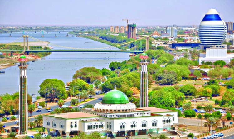
Khartoum is the capital and largest city of Sudan. It is located at the confluence of the White Nile, and the Blue Nile. Sudan was home to Nubian civilization.
The "Kush Empire" was the greatest of the Nubian kingdoms. In 1821, Khartoum was established by Ibrahim Pasha, the son of the then Egypt's ruler, Muhammad Ali Pasha. Sudan got independence from England in 1955. Sudan follows Muslim Sharia Law from 1983. Here 97% dwellers are Muslim.
For my assignments with United Nations (UN), I had to travel to Khartoum several times in the year of 2010. Khartoum International Airport is the main gateway to Sudan by air.
The airport is served by various European, Middle Eastern and African airlines. When flying over, the top view is spectacular and Khartoum looks like a decently international city. While the aircrafts descend the Nile become clearly visible. The White Nile and Blue Nile after merging at north of Khartoum continues to flow towards North.
Finally it falls into Medetraninan Sea. Various cultivation take place all along the bank. The distinct green catches eye. But at far the presence of desert sand can be identified from top. Coming out of the airport, anyone could feel the hot arid climate of Khartoum. Here, noticeable precipitation is observed only in the summer months. For accommodation, Indian house, Vijay hotel and Asian house were very much famous among sub continent visitors.
I visited Khartoum's largest open air market "The Souq Al Arabi" several times. Here varieties of curtains and blankets are available with cheap price. This is a classical chaotic market teeming with people. The market is divided into several sections, each focusing on a certain product.
There is even one block devoted to gold, although it certainly looks less sophisticated. The Great Mosque, which is also known as Mesjid al-Kabir is located just north of it. It is a very beautiful mosque built with red stone following unique Islamic architecture. It is nearly hundred years old. This mosque draws some influence from Persian, Roman, Byzantine, Chinese and Indian architecture. Thousands of minibuses gathering near the mosque are a sight to behold.
Describing Khartoum's traffic as chaotic is a bit of an understatement. The main train station of Khartoum is around 2 km south of this area. Rail communication connected mainly major cities in north, east, south and south west with Khartoum. Rail connectivity was developed as an adjunct to military expeditions in 18 th and 19 th century.
Afra Mall is the most modern shopping place of this city. It is located on Africa Road in the southern side of airport. Afra with its bowling alley, fun fair and movie theatre is the most entertaining place in the city. It has a supermarket, money changers and pre-paid mobile telephone kiosks. We found people enjoying time just outside the mall in the coffee shops and children's playground. Photographing is strictly prohibited in the city.
I also visited Souq esh-Shabi market, located in Omdurman area. I had to travel towards north- west after crossing Nile River. It is said to be one of the largest markets in Africa and famous for handicrafts. Most of the commodities are cheaper here. From here buses leaves for major cities like El-Obeid and Port Sudan. Here we noticed in many shops wood soaked in scented oils are burnt on colas. This smell makes coffee sipping experience more pleasant.
I tested local foods in street side shops several times. Locals take meals on a large communal tray where various meat, vegetable, salads are mainly served. These are eaten with flat bread or stiff millet porridge, known as asida. Many enjoy grill of fish or chicken as well.
Normally Most Sudanese take heavy meal at morning and evening. Tea served with spice or milk is very famous. Common types of coffees are locally known as qahwa and jebbana. The coffee is often spiced with ginger or cinnamon, and is drunk from tiny cups or glasses.
The egg-shaped Burj al-Fateh Hotel is an iconic structure, located on the southern bank of Blue Nile. I saw Tuti Bridge at the northern side of the hotel. It is a suspension bridge linking Tuti Island with Nile Street of mainland. At night it gives a magnificent look due to colorful and dazzling lighting.
Nile Street runs west to east, all along the southern bank of Blue Nile. It is probably the prettiest street in Khartoum. I came here several times to enjoy the beauty of Nile.
The L-shaped building has a conference hall, meeting room, exhibition gallery, theatre, and banquet hall. Egyptian embassy is situated at south of this building. Before my Egypt tour, I went there to complete visa formalities. By the by, Bangladesh does not have any embassy here. Rather a small consulate office is available close to University of Khartoum.
The National Museum is on western side of Friendship hall. On Friday and Monday the museum remains closed. The ground floor houses a good selection of antiquities of Nubian civilization. Instead of air condition large fans were placed inside the halls.
Presence of various colonial buildings, schools, hotels and government offices make it an aristocrat area. The sidewalk and rows of trees added beauty to this street. Many people sit on the concrete walls along the river. A children's theme park called "Al Mogran Park" is located at the end of this road. I found many date and bushy trees inside the park.
This park is a recreation spot with various rides. On the western edge, I saw a metal bridge connects Omdurman area. This steel truss bridge is supported by seven pairs of round pillars. Confluence of Blue Nile and White Nile can be observed nicely from this bridge.
One can actually identify the two different colors from the different branches of Nile. White Nile is much lighter brown then the Blue and I could see the two shades beyond.
The light brown water had travelled 3,700 km and the dark brown water 1,460 km. I was fortunate to see the source of White Nile in Uganda. Interested visitors can enjoy Nile cruise by boats moored at Tuti Bridge area. Since some restrictions are imposed on catching fishes, tasty and large size fishes roam around in the water.
From Tuti Bridge the Nile Street has gone further eastwards around 13 km upto Manshia Bridge, constructed over Blue Nile. Various ministries, residential areas and educational institutes are located in this part. The Presidential Palace is a pretty building but general people are not allowed to walk in front of it.
Besides other educational institutes campus of university of Khartoum is also here. Some foreign students are studying here, as the reputations of the universities are very good and the living expenses are low compared to other countries. Few small beaches are found on The Nile bank. Visitors enjoy calm family time there.
Several times I came across a type of intense dust storm, locally known as Haboob. This storm usually follows days of rising temperature. Vast sand layer totally shrouds the city. It destroys fertile soil. It forces authorities to cancel flights and shut schools.
Henna has been part of Sudan's social and cultural heritage from ancient time. Henna dyes are regarded with a special sanctity in Sudan. So, to celebrate happy occasions like weddings and Eid people get their hands and feet pigmented with this natural dye. Traditionally a Sudanese married woman uses henna for reasons like to endear herself to her husband and to appear in the public eye as a married woman.
Since long, Darfur region is facing clashes and crises. For finding a lasting solution UN is operating UNAMID mission there. It has a liaison cell in Khartoum. Bangladesh actively participated in this mission.
Many people opine that the word Khartoum is derived from Arabic word "khur??m", referring to the narrow strip of land extending between the Blue and White Niles. Civilizations in Sudan flourished along the Nile.
So, Nile is deeply involved with the history of Khartoum. Sudanese people are very hospitable. The present economic boom in Sudan has aroused travelers' interest to Khartoum which has been largely ignored as a travel destination over the years. Obviously, I had lot of wonderful memories during my tenure of tour of duties.
Mohammad Mahmudur Rahman Niaz is a civil Engineer and a serving Military Officer.
Email: [email protected]
Mohammad Mahmudur Rahman Niaz is a civil Engineer and a serving Military Officer.
Email: [email protected]