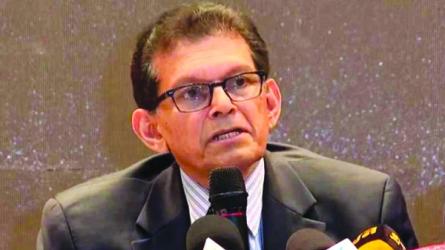
Hatia Islands, cluster of islands situated in the Meghna estuary of the Padma River (Ganges River) delta, southeastern Bangladesh.
The largest of these, South Hatia Island, is a low-lying land mass about 23 miles (37 km) long and 4-8 miles (6.5-13 km) wide. Only partially protected by embankments from sea incursions, it frequently is subject to cyclones and destructive ocean waves.
To the north-west, another large island of the Hatia group divides the Meghna River into two arms, the Shahbazpur River to the west and the Hatia River to the east. Smaller islands of the group lie to the west of South Hatia Island in the Shahbazpur River. The larger of the Hatia Islands are connected by ferry with the mainland.
How to go: After reaching at Noakhali district, go to chairman ghat by CNG or bus thenĀ use boat or other means of communication such as C-track to reach that Island.
How to reach: Noakhali district: Noakhali, a traveler's unique destination, is located in the South-Eastern part of Bangladesh. On the north, the beautiful district is bounded by Comilla, the Mehgna River. On its south, resides the Meghna River and The Bay of Bengal.
While Feni and Chittagong districts lie on the east, Lakshmipur and the Bhola districts are located on the west side. Dhaka and Noakhali districts are linked by road. You can take bus from Dhaka to reach Noakhali. Where to stay: Some places to stay in Noakhali areĀ Pubali Hotel, Hotel Al Morshed, Hotel Rafsan etc.